A View From Orbit of an Olympic Stage
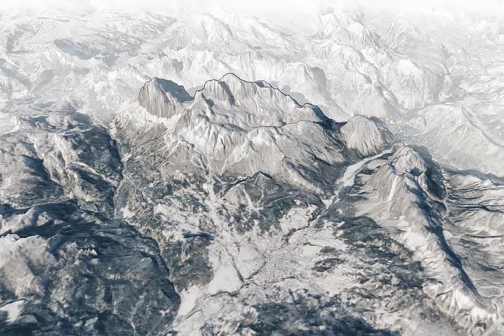
When the 2026 Winter Olympics and Paralympics open their alpine events in Cortina d'Ampezzo this month, competitors will race down slopes framed by some of the most dramatic mountain scenery anywhere on Earth. NASA's Earth Observatory has offered a striking preview, releasing a three-dimensional oblique map of the Italian Dolomites built from Landsat 8 satellite data captured on January 27, 2026. The imagery, acquired by the satellite's Operational Land Imager (OLI) sensor and overlaid on a digital elevation model, reveals the sharp limestone peaks, deep valleys, and sweeping snow cover that define this UNESCO World Heritage mountain range in northern Italy.
Cortina d'Ampezzo sits at the heart of the Dolomites, flanked by summits that exceed 3,000 meters (roughly 10,000 feet). The town and its surrounding slopes have been a destination for winter sports since the mid-20th century -- it hosted the 1956 Winter Olympics -- and the 2026 Games mark a long-awaited return to one of the world's most storied alpine venues.
Olympic Venues Carved Into the Peaks
The satellite imagery highlights the Tofana di Mezzo, a 3,244-meter peak that towers over the Tofane Alpine Skiing Centre. This venue will host the Olympic women's alpine skiing events as well as all Paralympic skiing competitions. The Olympia delle Tofane course drops 750 meters from start to finish and features the Tofana Schuss, a chute with gradients reaching 33 degrees that has tested elite skiers for decades.
Other Olympic infrastructure is also visible in the broader landscape. The Cortina Sliding Centre, which will host bobsled, luge, and skeleton competitions, has been rebuilt on the site of the track originally constructed for the 1956 Games. Nearby, the Cortina Curling Olympic Stadium -- which served as the figure skating venue nearly 70 years ago -- has been repurposed for curling. The combination of legacy venues and modern upgrades reflects the Cortina organizing committee's strategy of blending heritage with contemporary standards.
Snow Conditions and Climate Challenges
The Landsat 8 imagery, rendered in false-color composites, shows extensive snow coverage across most of the terrain, with forested areas and exposed cliff bands creating vivid contrasts. The snowpack is significant, but the season has not been without concern. Early-winter snowfall in the Dolomites was below average, raising questions about course readiness. A substantial storm on February 3 delivered relief, blanketing the region and improving conditions across the alpine venues.
Modern Olympic skiing, however, does not rely solely on natural precipitation. Automated snowmaking systems, many powered by renewable energy sources, supplement natural snowfall to maintain consistent racing surfaces. These systems represent an increasingly critical component of winter sports infrastructure as climate variability makes natural snow less predictable in traditional alpine regions across Europe.
Why It Matters
NASA's Earth Observatory imagery serves a purpose well beyond the aesthetic. The Landsat program, now in its fifth decade, provides continuous global monitoring data that scientists use to track land use changes, glacial retreat, vegetation health, and urban expansion. Capturing the Dolomites in the context of the Winter Olympics illustrates how satellite remote sensing can document human activity at landscape scales -- from the construction of Olympic venues to the snowpack conditions that determine whether events can be held safely.
For the athletes descending the Tofana Schuss at speeds exceeding 100 kilometers per hour, the view from orbit is the farthest thing from their minds. But the data that made this image possible is part of the same observational infrastructure that monitors the long-term health of the mountain environments where winter sports depend. As the climate continues to shift, that monitoring will only become more important.


